Stay ahead of U.S. digital delivery mandates with Dalux InfraField, powered by the world’s leading BIM viewer and seamlessly integrating 2D, 3D, and geospatial data into one collaborative construction management tool.


Dalux InfraField is a mobile-friendly, openBIM-based field management tool, built for roads, rail, bridges, and utilities projects.
Connect office and field teams in real time, ensuring your project documentation is accurate, compliant, and future-proof.
Dalux InfraField is vendor-neutral and works seamlessly with models and drawings in IFC, Revit, Navisworks, and other formats, eliminating compatibility issues and data silos on your projects.
Future-proof, delivering open-standard data in IFC format that every stakeholder can access and understand.
Collaboration-ready, keeping project members aligned on a single, accurate data source.
State DOTs and federal agencies are adopting MALD (Model as a Legal Document) standards. Dalux InfraField helps you meet these new requirements.
Connect field inspections directly to your IFC model, ensuring data is structured.
Provide time-stamped, geo-referenced documentation for audits and legal reviews with complete transparency.
Provide a mobile-first experience, ensuring your teams can access critical project data anywhere.
Gather earthwork volumes easily to help you plan and manage the quantities you need.
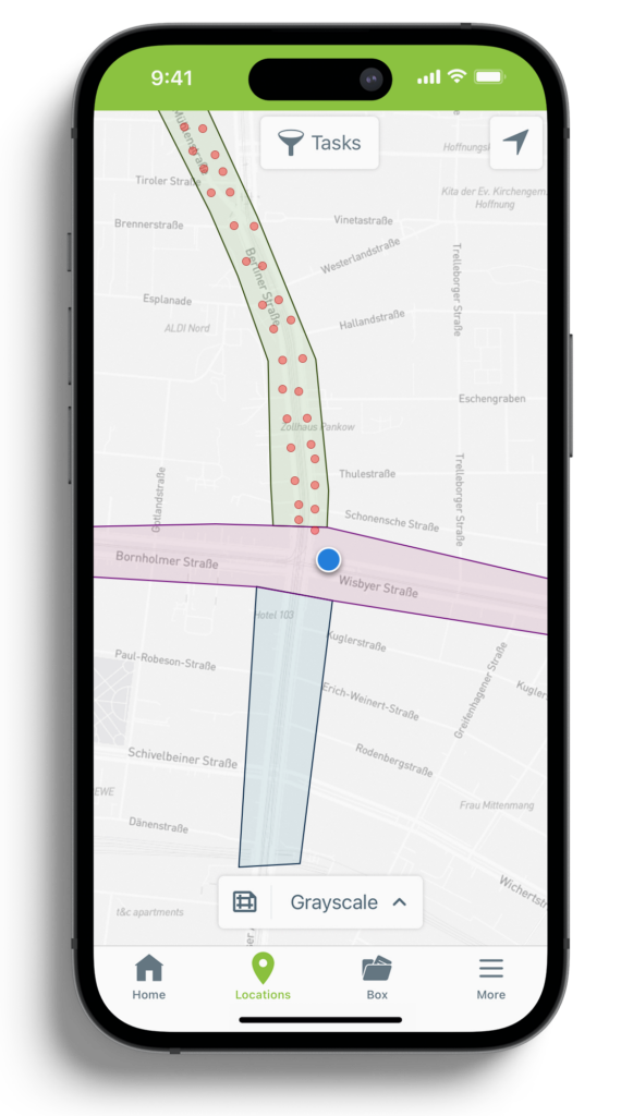
Capture geo-tagged tasks, photos, and markups directly on maps or models for complete traceability.
Dalux InfraField supports high-resolution orthophotos, giving field teams a real-world, geo-referenced view of the site.
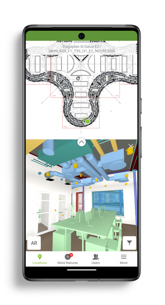
Bring your data together from various BIM model formats including IFC, 2D drawings, orthophotos, and quantity data from surveying. The data is placed automatically on the model and you, and your team can write notes on-site.
Connect field and office teams in real-time, capture inspections and updates directly on the model. Generate specific checklists at set distances along an alignment and automatically pull in the relevant GIS metadata.
Maintain full traceability of all tasks and bring miles of information together in a single touchpoint.

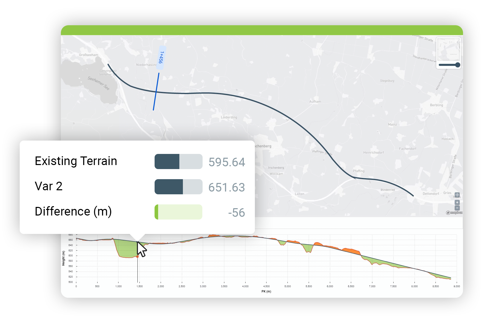
Not just the simple element quantities from traditional structures, you can also get the earthwork volumes to help you plan and manage works on site.
Understand volume differences between 3D surfaces within Dalux, including calculating volumes of stored excavations on site.
Create an interactive visual that shows earthworks along an alignment and quickly see where the cut and fill takes place.
With a consistent map view highlighting your location using your mobile phone’s GPS, you’ll know where you are on a civil or infrastructure project of any scale.
The simple interface also allows users to experience infrastructure projects in a new way and see 3D models in the spatial context of GIS data, bringing immediate value to the construction of linear assets.
Are you interested in learning more about openBIM, IFC workflows, or the MALD framework?
Our local team is ready to show you how Dalux can fit seamlessly into your current tools while streamlining your construction process.
A BIM Viewer a leggyorsabb és legjobb módja annak, hogy a BIM modelleket az összes projekttag kezébe juttassa, akár az építési területen.
Köszönjük, hogy regisztrált!
Nyissa meg levelezési postaládáját, hogy hozzáférjen a Dalux projektjéhez és befejezze a regisztrációt!
Our BIM Viewer is the fastest and best way to get your BIM models on site and in the hands of all project members.
Thanks for signing up!
Go to your email inbox to access your Dalux project and finish the registration.